About Swiss Drone Maps
Pilots of drones and model airplanes can use Swiss Drone Maps to catch up on where they are allowed to fly. No-fly zones and controlled traffic regions are specifically coloured on the map and therefore easily visible....
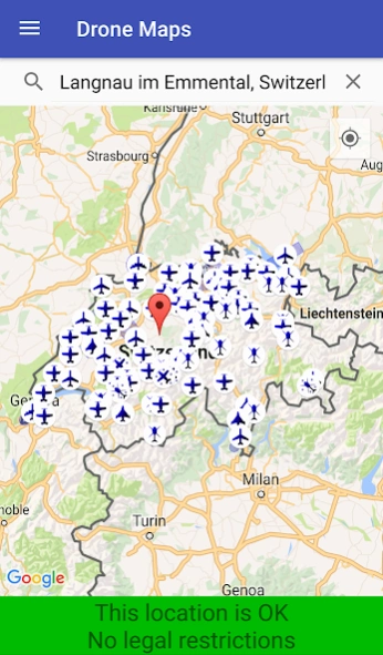
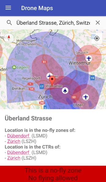
Pilots of drones and model airplanes can use Swiss Drone Maps to catch up on where they are allowed to fly. No-fly zones and controlled traffic regions are specifically coloured on the map and therefore easily visible. Airports and heliports are clearly visible thanks to intuitive markers on the map.
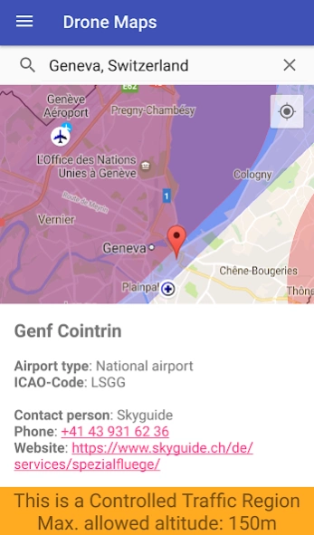
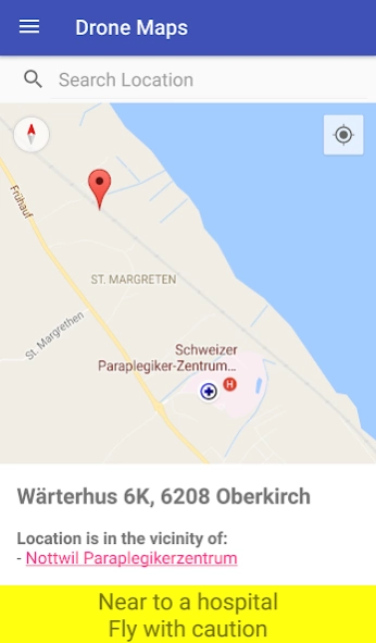
At higher zoom levels, the map shows relevant additional information such as hospital and mountain airfields. The selection of a site marker shows not only information about the area but also the phone number and website of the airport. This contact data allows for spontaneous and easy applications for special flight permits.
The app also informs about the current Swiss legal situation for remotely piloted aircraft systems (RPAS).
For the future, e.g. the following additional features are planned:
- Apply for Skyguide flight permissions for drones and model airplanes directly within the app.
- NOTAM and DABS: Current changes in Swiss airspace relevant for drones and model airplanes
We cannot guarantee correctness to 100% and refuse any accountability.
Previous Versions
Here you can find the changelog of Swiss Drone Maps since it was posted on our website on 2019-10-13 05:19:41.
The latest version is 19.4 and it was updated on 2024-04-22 14:50:36. See below the changes in each version.
Swiss Drone Maps version 19.4
Updated At: 2023-09-07
Changes: Updated Libraries and Dependencies
Swiss Drone Maps version 19.3
Updated At: 2023-05-09
Changes: Change for data protection compliance
Swiss Drone Maps version 19.2
Updated At: 2022-12-31
Changes: Updated obstacle data
Swiss Drone Maps version 18.3
Updated At: 2022-02-22
Changes: Updated libraries, dependencies, etc.
Swiss Drone Maps version 18.1
Updated At: 2021-10-24
Changes: Updated DJI Data
Swiss Drone Maps version 17.9
Updated At: 2021-08-28
Changes: Small UX fixes for weather-data
Swiss Drone Maps version 17.7
Updated At: 2021-05-25
Changes: Improved data for local restrictions
Swiss Drone Maps version 17.3
Updated At: 2021-04-03
Changes: Improved text in unknown area to make it clearer that the app only works in Switzerland (and that this is intended).
Swiss Drone Maps version 17.0
Updated At: 2021-02-23
Changes: Improved DJI data and the usability of the its display.
Swiss Drone Maps version 16.8
Updated At: 2021-02-13
Changes: Added a new, experimental, feature: The app now allows the user to switch between the normal map showing legal restrictions in Switzerland and a new map showing restrictions imposed by the manufacturer DJI for its drones.
Disclaimer
Official Google Play Link
We do not host Swiss Drone Maps on our servers. We did not scan it for viruses, adware, spyware or other type of malware. This app is hosted by Google and passed their terms and conditions to be listed there. We recommend caution when installing it.
The Google Play link for Swiss Drone Maps is provided to you by apps112.com without any warranties, representations or guarantees of any kind, so access it at your own risk.
If you have questions regarding this particular app contact the publisher directly. For questions about the functionalities of apps112.com contact us.